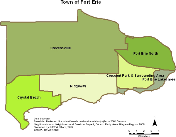
The neighbourhoods were identified through the Neighbourhood Creation Project (Ontario Early Years Niagara Region, Niagara Region Public Health Department - 2006). The map was created by UEY (2007), in partnership with the Data Analysis Coordinator at the Regional Municipality of Niagara and the Offord Centre for Child Studies at McMaster University. Base features for the map were created by the PREP Unit, Public Health. The neighbourhoods are outlined in brown.
We have also worked closely with the Early Years Niagara Research Advisory Group and the Niagara Region's Ontario Early Years Data Analysis Coordinator to make decisions on how best to report the information given mandated restraints (i.e. neighbourhood samples with less than 30 children cannot be reported on in order to protect confidentiality and privacy).
"The Town of Fort Erie possesses a uniquely rich community heritage and natural environment, and an unprecedented combination of pre-historic, historic and contemporary landscape features."
Copyright © 2007 Town of Fort Erie
Click here for more information on the Town of Fort Erie. 
"Located in the Niagara Peninsula's southwestern corner where Lake Erie enters the Niagara River, Fort Erie offers the best of both worlds blending small-city living with the convenience of two large metropolitan areas, Toronto and Buffalo, just a short drive away. ... Fort Erie's colourful heritage, unique geography and modern city services make us an attractive year-round home for approximately 30,000 people and seasonal home to 10,000 more who flock to beachfront properties for the summer."
Copyright © 2007 Fort Erie Econiomic Development and Tourism Corporation
Click here for more information on the Fort Erie Economic Development and Tourism Corporation.![]()


